 Translate
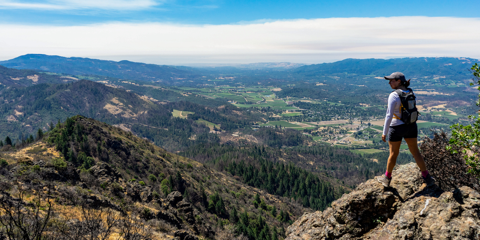
Three Sonoma County trails to inspire gratitude and introspection
By Regional Parks staff
Taking to the trails is an opportunity to find gratitude in the beauty of the outdoors and prioritize your mental and physical well-being. The diversity of Sonoma County’s regional parks ensures that you’ll find trails suitable for all skill levels and preferences and the perfect place to gain perspective on what matters.
How to do a “gratitude hike” (or ride) anywhere
The three routes below are meant to spark inspiration, but you can plan your own gratitude hike anywhere. Just choose a favorite trail, and as you walk or ride, take moments to reflect on the things you're thankful for, letting the landscapes inspire you. Pause for some deep breathing or close your eyes for a brief mediation; consider bringing a journal to jot down your thoughts. As always, wear sturdy footwear, carry water, follow park rules, and leave no trace to preserve these natural spaces for everyone to enjoy.
Three Sonoma County trails we're thankful for

Valley of the Moon Trail at Sonoma Valley Regional Park
Distance: About 3 miles out and back
Difficulty: Easy; paved
The Valley of the Moon Trail is the main trail in Sonoma Valley Regional Park in Glen Ellen. With its relatively flat terrain and gentle inclines, it's a perfect trail for those seeking a mellow outdoor experience.
Starting at the main parking lot, the Valley of the Moon Trail guides you through oak woodlands and meadows. The palette of the landscape changes with the seasons, offering bright wildflowers in spring and golden leaves with hanging lichen in the fall. A shallow creek flows along the trail in winter and spring. Listen to the rustling leaves and bird songs and stop at one of the benches along the trail to rest or journal. At about 1.5 miles, the trail ends at Arnold Drive, where you simply turn around to return to the parking lot. There is a picnic area near the main parking lot, making it a great place to enjoy a lunch afterwards.

Overlook Trail at Helen Putnam Regional Park
Distance: About 2 miles (round trip)
Difficulty: Moderate, dirt or paved
There are several ways to reach Helen Putnam Regional Park's scenic “Overlook Point”, which on a clear day provides panoramic views of Petaluma and the surrounding countryside. This is a quiet spot to contemplate past and future accomplishments and hold space for gratitude.
If you enjoy the charm of traversing switchbacks, with expansive views peeking through strands of oaks, start from the Windsor Drive parking lot. If you favor a gentler ascent, park at the Chileno Valley Road lot, where the paved section of the Ridge Trail is more gradual and perfect for the wet season when dirt trails turn muddy.
From the Windsor Drive parking lot: The West Wind Trail leads you along several switchbacks to the crossroads with Filaree and Pomo trails. Take Filaree Trail, which winds .4 miles to the Ridge Trail, and then take a short spur to Overlook Point where a bench provides a spot to take in the view. Return by retracing your steps or connect with another trail to make a longer loop (see the map).
From the Chileno Valley Drive parking lot: The paved section of the Ridge Trail begins just past the restrooms, gently ascending with views of rolling pastures and hills. After about a half mile, the trail passes Cattail Pond, a lovely spot for a picnic or a moment of reflection. Continue your climb for another .6 miles to reach Filaree Trail and take the short, unpaved spur trail to Overlook Point. Pause here to soak in the scenery and take a moment for reflection and gratitude. Return by retracing your steps or connect with another trail to make a longer loop (see the map).

Gunsight Rock via Lower Johnson Ridge Trail at Hood Mountain Regional Park and Open Space Preserve
Distance: About 8.8 miles (round trip)
Difficulty: Strenuous, dirt
A hike to Gunsight Rock at Hood Mountain Regional Park and Open Space Preserve is a challenging adventure, and the reward is stunning panoramic views of Sonoma Valley, Sonoma Mountain, San Pablo Bay and beyond. Hood Mountain's summit is the highest peak between Sonoma and Napa valleys at more than 2,730 feet. Be prepared for a climb of more than 2,000 feet, taking around 4.5 hours roundtrip. Thanks to its rugged trails, this park tends to be less crowded, especially on weekdays. We recommend traveling with another person, wearing proper footwear and gear, bringing a map (or taking a photo of the one at the parking lot kiosk), and plenty of water. (The park does not have potable water).

Begin at the Pythian Road parking lot and head uphill on Lower Johnson Ridge Trail, enjoying the sounds of the oak woodlands and the creek canyon. Here, a steep, but short .3-mile section of the trail is on a paved access road; follow the trail signs to find the dirt path again. After about 1 mile of steep climbing, you'll come to a (usually) shallow ford crossing Hood Creek. This area burned twice in the 2017 and 2020 wildfires, so you’ll see signs of burn and recovery. In fact, portions of the park served as firebreaks that helped stop flames from reaching more populated areas – another reason for gratitude.

Stay on Lower Johnson Ridge Trail, then take a right on Pond Trail, which gives you a little break from climbing and meanders past Merganser Pond and Hood’s backcountry campground. Picnic tables and a restroom here provide a good break spot.
From Merganser Pond, follow Valley View Trail where views of Sonoma Valley begin to open up. You'll continue climbing to rejoin Pond Trail, then at Orchard Meadow take the Upper Johnson Ridge Trail to Hood Mountain Trail, where the terrain changes from forest to open chaparral. Continue uphill on Hood Mountain Trail toward the summit.
The views from the summit are only partial due to dense foliage, so at the summit, take the Summit Trail, a right on Nattkemper Trail and then a right on the spur trail to Gunsight Rock – a rock outcropping where you can take a well-deserved rest with spectacular views.

Gunsight Rock is a good place for a rest and a picnic; but it’s rugged, exposed and can get a little windy, so watch your step and stay back from the ledges. While here, take a moment to reflect on your accomplishment and watch turkey vultures soar on the thermals. When ready, turn around and head back the way you came, embracing the feeling of gratitude that comes with heading downhill … all the way back to the parking lot.
While hiking these trails in Sonoma County Regional Parks, we hope you find inspiration in the natural beauty, history and preservation of these spaces for future generations. Consciously holding a space for gratitude while on the trail can turn it into a transformative experience, fostering a deeper connection with nature and others.
All of these trails are open to hikers, bikers and equestrians. Parking is $7 or free for Regional Park members.
Published November 2023