Hiking to Hood Mountain Gunsight Rock after the Wildfire
If you haven’t been to Hood Mountain Regional Park in a while, now is the time to go.
The Pythian Road entrance of the 1,750-acre preserve recently reopened for the first time since the October 2017 wildfire, and its landscape offers a unique look at both the ferocity of the fire and the resiliency of nature.
Hood Mountain enthusiasts who have been waiting to hike to the 2,700-foot summit above the Sonoma Valley will be relieved to know that their beloved getaway is not ruined, but regenerating – undergoing a “renovation” of sorts. For months after the fire, parks staff, partners, and contractors worked to assess burned trees, repair trails, reinforce retaining walls and rebuild culverts to get the park open.
A Forest of Green, Brown & Black

Despite felled trees and burnt trunks – some of which appear to have burst in the heat of the flames – vibrant greenery fills many areas of the lower elevations. Hood Creek hums its tune along the Lower Johnson Trail and crescendos when it engulfs the path and tumbles over the nearby ledge to the ground below. It’s shallow and easy to cross, though if you are captivated by the cooing waterfall, you might miss the large pieces of wood that create a makeshift bridge to the other side.
The park is alive with the sounds of visitors trekking up its steep incline. Leashed dogs pull their owners up trails, wildflower buffs scour meadows, and horses carry riders along the paths. As you walk the forested lower half of the park, it looks as though a child colored the area using three large crayons – one green, one brown, and one black. There is a mixture of life and death all along the trail, but mostly life.
Burnt Matchsticks
So what has changed? Honestly, a lot. You’ll realize this when you emerge from the tree cover, about a mile below the summit. Unlike other burned parks, Hood Mountain’s upper elevations were seared by flames so hot they scorched the ground completely, reducing swaths of conifer forest to ash and black matchstick trunks.

The difference between the pre- and post-fire landscape is shocking. During the firefight, crews made a stand on Hood Mountain by carving wide breaks across its ridge, including through the pygmy forest. After the fire, they covered the break with the slashed remains of the cypress, manzanita and knobcone pines. It's as if the child who so carefully colored the trees below threw a tantrum and stomped much of the stunted forest into oblivion.

Continuing beyond the pygmy forest, you'll pass slopes that are totally blackened and others where only the understory is singed. You will notice burn scars, bulldozer scrapes, and erosion-control efforts. But more importantly, you will see signs of life. From sprouting soap root and wildflowers – whose vibrant colors are only made brighter by the surrounding char – to western fence lizards that dart across your path, the devastation becomes somewhat beautiful, as it has created this new growth.
The “Undead” Forest

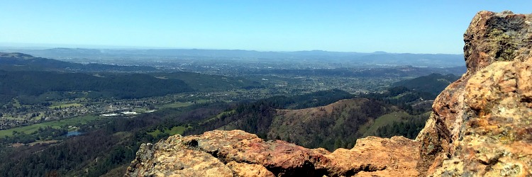
When you reach the summit, you’ll now know that you’ve reached the summit. Prior to the fire, chaparral blocked the view here, which is why many people opted to continue on to Gunsight Rock for an unobstructed panorama of Sonoma Valley and beyond. Now, what remains in the summit sightline are thin, brown, twisted branches – easy to see through yet hard to miss. Venturing down to Gunsight Rock is like walking through a crowd of zombie trees that look dead but could come alive with time, the “undead forest,” if you will. Beneath it, the blackened soil is brimming with growth.
Signs of Life

In life, change is not easy, and starting over takes time. The fruits of our labor are often not noticeable until we have accomplished our goal. Nature, however, offers immediate evidence and satisfaction when beginning anew. Between the charred trunks, you will find the hints of regeneration you hoped would be there. Oak and bay laurel shoots sprouting from root crowns, scarlet fritillary and Indian warrior blooming along trails, a mountain lion paw print etched in the soil. Signs of life.
Plan Your Visit
To hike this side of Hood Mountain, begin at the upper parking area at 1450 Pythian Road in Santa Rosa. (Pythian Road is along Highway 12, across from the Oakmont community.) Follow Lower Johnson Ridge Trail to Panorama Ranch Trail, to Hood Mountain Trail to Summit Trail and down to Gunsight Rock. Roundtrip is approximately 8 miles and elevation gain is 2,000 feet. Parking is $7 or free for Regional Parks members.
Tips for conquering Hood Mountain
- Adhere to all trail signs and stay out of closed areas.
- Bring plenty of water because there is none available at the park.
- Carry the park map or use your phone to take a picture of the map posted at the trailhead.
- Pack a hat and sunscreen and dress in layers.
- Avoid hiking in the mid-day heat.
- And most of all, enjoy the view.
Janelle Wetzstein is a marketing specialist for Sonoma County Regional Parks.
 Translate