Andy's Unity Park - Background
History of the Park Site
A park has been envisioned for the Moorland Neighborhood area for many years. There are no parks within a half mile of the Moorland site, which is the typical neighborhood park service area. In fact, the closest park is Southwest Community Park, more than 2 miles away. During the 1990s the developer of the Parkview subdivision to the north had proposed a second phase of construction which was to include a small neighborhood park. The streets and utilities were built, but the project was never developed as proposed. The property was declared in tax default for non-payment of delinquent taxes and was acquired through tax liens by Sonoma County and purchased by the Sonoma County Parks Department in 2014.
Based on historical topographic maps, previous to the development of Horizon Way and the Parkview subdivision, the park site contained a working orchard and farmstead including bungalow, barn and associated out buildings dating back to 1916. At some point between 1972 and 1982 the farm house and barn were removed, but the orchard remained. The Northwestern Pacific Railroad tracks have existed along the western boundary through the entire period documented by the historical maps (78 years). A cultural resource report and environmental assessment report are available below and provide more detail about the history of the park site.
The topography of the park site is generally flat with elevations ranging from 108 to 112 feet above sea level. The vacant lots are dominated by disturbed, non-native grassland and is interspersed with small stands of apple trees, which appear to be the remnants of the former orchard. A seasonal wetland is identified in the southern area of larger parcel which and encompasses .45 acres. A complete Biological Resource Assessment is available below.
Resources:
- Biological Resources Assessment(PDF: 9.6 MB)
- Phase 1 Environmental Site Assessment(PDF: 15.6 MB)
- Archaeology Survey Report(PDF: 3.5 MB)
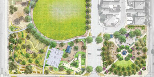
The Plan for the Park
Andy’s Unity Park grew from a community’s commitment, perseverance and belief in the healing power of a park. The plan for the park remembers the life of Andy Lopez, who was tragically killed at the site, and also celebrates community unity, and youth empowerment while providing a variety of features for neighborhood residents and families to gather and play.
The Moorland Healthy Neighborhood Plan created with the Neighborhood Advisory Team identified “creating a park” and “creating safe places for children to play” as two of the highest priorities for the neighborhood, and the creation of Andy’s Unity Park will make this possible, satisfying a long term need for the neighborhood. The plan for the park includes: a natural turf field, a basketball court, a skate area, play area, picnic and gathering spaces, a community garden, pathways, natural spaces and a memorial garden offer opportunities for peace and reflection.
Project Funding
Funds for the project were provided by a combination of grant funds including the California Department of Housing and Community Development, Housing Related Parks Program, and the Sonoma County Agricultural Preservation and Open Space District, Matching Grant Program, with the addition of County general funds.
 Translate