Hood Mountain Bay Area Ridge Trail - Background

Bay Area Ridge Trail (BART) Background
The vision for the Bay Area Ridge Trail is 550-miles of continuous trail serving hikers, mountain bicyclists and equestrians that rings San Francisco Bay high on the ridgeline.
Under the leadership of the Conservancy and Bay Area Ridge Trail Council (BARTC), and supported by a diverse group of project participants, the Ridge Trail creates an interconnected system of open space and trails that provides recreational opportunities and scenic views to the public. In its over 20 years, more than 340-miles of trail have been opened to the public in all nine Bay Area counties.
Project Description
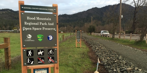
The Bay Area Ridge Trail Extension Project provides a critical link in the Ridge Trail, connecting Hood Mountain Regional Park & Open Space Preserve with the City of Santa Rosa and Annadel State Park. This vital piece includes construction of 0.3 mile segment of the Ridge Trail with improvements to facilitate a safe and accessible crossing of Highway 12 at Pythian Rd. The trail portion of the project is located on vacant land that is part of the County-owned Los Guilicos complex and was formerly agricultural land dominated by annual grasses.
 Regional Parks has constructed a multiple-use pathway from the existing end of the Ridge Trail at Rancho Los Guilicos Road to State Highway 12 on the existing County-owned Los Guilicos complex. Before the trail was completed, pedestrians used the roadway between the highway and the facility. The trail is now separated from motorized vehicle traffic, providing a safer route of travel. The pathway is a six foot wide compacted gravel surface with gentle grades making it compliant with the Americans with Disabilities Act (ADA).
This short critical stretch of trail was necessary to provide a connection to the greater Ridge Trail. To the north, the trail connects to an existing, dedicated segment of the Ridge Trail which links to Hood Mountain Park and all its trails. To the south, the project connects to the subdivision of Oakmont in the City of Santa Rosa, providing access beyond to Annadel State Park.
The public can now easily access existing open space and an extensive existing trail network on either side of Highway 12. In addition, the trail supports the use of alternative transportation as it connects to Sonoma County Transit bus stops along a bus route linking the cities of Santa Rosa and Sonoma, and provides access to the numerous facilities at the County’s Los Guilicos complex.
Project Funding
The Bay Area Ridge Trail Council grant in 2008 provided funding for project planning, environmental review and engineering.
The State Coastal Conservancy grant in 2012 and Park Mitigation Fees provided funding for project construction.
Volunteers contributed to the project providing labor for tree planting and tree protection along the trail corridor.


 Translate