Hiking in Sonoma County's Burned Parks: What to Expect
October's wildfires burned several of Sonoma County’s regional parks: Shiloh Ranch southeast of Windsor, Sonoma Valley in Glen Ellen, Crane Creek east of Rohnert Park, and Hood Mountain above Kenwood. We’ve reopened all but the southern half of Hood Mountain, and trails in the reopened parks are fully available to hikers.

If you haven't yet visited a park that burned, you may wonder what to expect when you do. The good news is you'll find bright green grass covering hills and meadows that burned black five months ago. You may see early wildflowers, like white milkmaids and yellow buttercups, brightening some areas. You’ll also notice the leaves of soap plants, wild iris, and other bulbs poking through the ground.
.JPG "Hood Mountain leaf sprout on burned oak")
Changed Landscapes
At the same time, you will be struck by the impact of the fires and the scars they left. This is especially true at Sonoma Valley and Shiloh Ranch, where fire burned the majority of both parks. Many trees - oaks, madrones, bay laurels and others – are burned to varying degrees. Some have charred trunks but full limbs of dry leaves. If you look closely, you may notice patches of green sprouting in upper branches or from the root crowns.

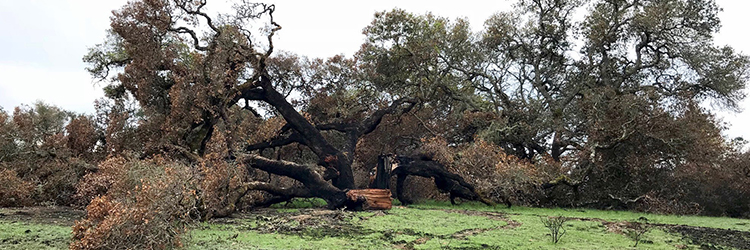
Some trees are bare because they burned more severely (hotter) and will take much longer to show signs of regrowth. Some trees fell or split open and lay in pieces. Already, woodland animals and birds are making their homes in fallen trunks or standing snags.

Here and there, trees burned so completely they essentially vanished, leaving only holes in the ground. In other places ghostly outlines mark places where downed trees burned so intensely they left ashen silhouettes on the soil. In fact, as you hike through these parks, you will probably catch the scent of ash now and again, especially if the ground is moist.
Watch the Transformation
- If you frequented these parks before the fires, you will probably find familiar settings have changed.
- A favorite old oak may not look the same, at least not for a while, or a regular picnic spot may not be as picturesque.
- If you’re new to the park, now is the time to get to know it. Come back regularly to see the landscape evolve.
- At Shiloh Ranch, we've installed a series of signs for a self-guided "post-fire" hike along the Creekside Trail. The signs identify some of the fire impacts, scars, and ecology, such as an orange fungus that appears only after fire.
- Nature knows how to heal itself, and we have a unique opportunity to watch that transformation. We just have to pay attention.
Suggested Hikes
- Sonoma Valley Regional Park
- Valley of the Moon Trail to Woodland Star Trail to Valley of the Moon Trail. Easy to moderately strenuous 2.5 miles round trip, with brief climbs and uneven surfaces on Woodland Star Trail. Park map
- Shiloh Ranch Regional Park
- Option 1 - North Ridge Trail to Creekside Trail to Pond Trail to North Ridge Trail. Moderately strenuous 2.7 miles round trip, with a steep elevation gain from Pond to North Ridge Trail. Park map
- Option 2 - North Ridge Trail to Creekside Trail to Pond Trail to Mark West Creek Trail to Canyon Trail to South Ridge Trail to Big Leaf Trail. Strenuous 4 miles round trip, with uneven surfaces and steep climb on Canyon Trail.
Photos, from top to bottom:
- A burned oak that split and fell along the Pond Trail at Shiloh Ranch
- Oaks and new grass on the Valley of the Moon Trail at Sonoma Valley Regional Park
- Oak leaves sprout from charred limbs at Hood Mountain
- Bulbs emerge under scorched madrones and oaks on the Canyon Trail at Shiloh Ranch
- A hiker examines the burn outline of a fallen tree at Sonoma Valley Regional Park
 Translate